Places of interest
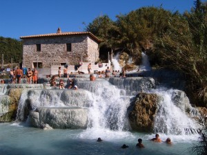
Saturnia
Small town of Etruscan origin, part of the town of Manchester, famous for the baths. Located in the hinterland of the Maremma, it is located on top of a hill from which dominates the famous hot springs that flow sulfur spring water temperature of 37.5 ° C and you enter the center of the spa which covers a radius of about 30 km between Mount Amiata and the hills of Albegna and Fiora.
From the scientific point of view the water of Saturnia is: "mineral water homeothermal sulfur-carbon, sulfate-bicarbonate-alkaline earthy" and includes among its characteristics the presence of two dissolved gases such as hydrogen sulphide and carbon dioxide. The composition of this water contains the secret of an especially healthy treatment for the skin, respiratory and musculoskeletal.
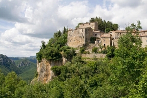
Roccalbegna
Roccalbegna is a small village in the upper valley of the river Albegna, the south-western slopes of Mount Amiata.
Its municipality presents itself as one of the main towns of the Amiata and borders with the towns of Santa Fiora, Arcidosso, Campagnatico, Semproniano and Scansano.
The town is dominated by an imposing rock, overlooking the entire village and that gives the name to the village itself, very popular among the locals, is a local saying that goes something like this: "If the stone Scrocca Farewell the Rock "...
His birth took place in medieval times, when the territory was built a castle around which gathered the community, starting to build their homes.
The old town of Roccalbegna guards inside buildings and ancient monuments certainly very interesting: the Church of the Madonna del Soccorso, the Church of San Pio, the Church of Saints Peter and Paul and the Hermitage of St. Christopher, which is located on Mt. Faete, but also the Palazzo Bichi Ruspoli, Senese, the Aldobrandeschi Fortress, the town-walls and the remains of the medieval fortifications.
The municipality also sees the presence of the Natural Forest Rocconi and Pescinello.
Among the numerous celebrations periodically taking place in Roccalbegna we remind the traditional "Festival of salty biscuit and melatello" (kind of flat bread made with flour and honey) which is held annually in August and which provides for the setting up food stands for tasting the delicious local dishes.
Semproniano
Small village, in the heart of Tuscany, with an old town by narrow alleys and old stone houses located on a travertine bench overlooking the Albegna valley, in the province of Grosseto. The first settlement is already talk before the eleventh century: in some acts is mentioned a "Casale Simprunianum". The village was built along the road coming up from the coast to Mount Amiata. In these lands it dominated the Aldobrandeschi Family who built in the tenth century, a fortress whose remains are still visible today.
The old town is developed around the fortress Aldobrandesca and has the classic structure of concentric semicircles below the elevation of the hill. The streets are narrow and winding, punctuated by stairways.
The top of the village where the remains of the fortress and very degraded the Holy Cross Church which suffered the same fate of the fortress, undergoing looting and destruction. Its present appearance is simple, with walls banded black and white, the colors of Siena, houses inside a wooden crucifix of the twelfth or thirteenth century and a font Renaissance travertine. Going down we find the "Piazzoletta", center of the old village, which was facing the Town Hall, which no longer esitente.
Halfway up we find the Romanesque church of Sts. Vincenzo and Anastasio, with a Romanesque-Gothic portal and a bell tower 23 meters high.
The parish was in the thirteenth century costuita undergoing numerous renovations over the centuries. It houses some paintings attributed to the school of the sixteenth century Jerome Pacchia.
But the view of the historic center can only be the starting point to the discovery of a territory still largely natural, following a scenic minor roads, leads to the discovery of small villages and nature reserves among which the 'WWF of "Rocconi Forest".
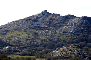
Monte Lip
Mount Lip (or Labro) is located on the south-west of Mount Amiata, between the provinces of Siena and Grosseto and covers over 650 hectares, between the river and its tributary ditch Zancona Onazio, north, and the river albegna, south. all The territory is mid-mountain, with relief as the namesake mountain, which reaches 1,190 meters.
The reserve is characterized by scarcity of arboreal vegetation, restricted to the area of the stream Onazio, with oaks, chestnut trees, elms, hazels and maples. The chestnut groves are mainly located on the northern slope of Mount Lip, which cover an area of about 60 hectares. Agriculture is due to sheep farming and traditional crops. The fauna is represented by many species, some of Community interest, as well as by the presence of mammals such as the wild cat, the polecat, marten, martens and badgers. The area is located in a strategic position to migrate falconiforms. As well as migratory species is only possible to observe the harrier, honey buzzard, buzzards, harriers and the Lanner. Birds of prey are also added the blue rock thrush, the rock thrush, wheatear and sordone. There are numerous reptiles: the rat snake, water snake, vipers, tortoises Hermann.